.        .
MENU SELECTION:  The Italian Campaign At The Front Books Armies Maps 85th Division GI Biographies Websites

Dated:   Feb 8, 2009

Birth, Life, and Death
of a Small Town’s Railroads

By Newton Cole and Marie (Oswalt) Nutt

Locating the Southern Railway of Mississippi and
the Yazoo and Mississippi Valley Railroad
in relation to the towns of
Minter City, Schlater, & Phillip

   
It has never failed – I become interested in a history of something after I move away from that geographic region.  It happened with Civil War history.  After I moved to Petersburg, Virginia, during the waning days of the Civil War Centennial, I became interested in the subject.  Only then did I realize that I had lived all my life in a state that had a great wealth of such history. 
Newton Cole   


THE DEPOT

  Now I have found the same happening with the history of railroading in my very small hometown of Minter City, Mississippi.  I got re-interested in model railroads about seven years ago.  I began researching railroading in Mississippi since I wanted to ‘locate’ my small HO scale layout in that state.  Soon I became interested in the Yazoo and Mississippi Valley Railroad (Y&MV) because it ran through much of the deep woods, swamps, and fields I had known as a kid. The Y&MV became a wholly-owned subsidiary of the Illinois Central about 1882. After searching some libraries in my adopted state of Texas and in my home state on visits, I did not find much at all about the rail line.  That all changed when I joined the Illinois Central Historical Society and ran into persons who had heard of the Y&MV and were willing to share their knowledge.  It is to them that I am eternally grateful.  It was not long before I had a lot of information and background but not enough true understanding.

    As I found information on the Y&MV I found myself corresponding with an old friend from the same town.  Marie (Oswalt) Nutt, a woman a few years younger than me, had lived some of her childhood in the second story living quarters of the depot in that small town.  Her dad, Jesse Oswalt, was the station agent.  I decided I wanted to know more about that depot and the town in the context of the rail lines that ran through the area.  Marie and I, working from long distance, decided we wanted to see if we could ‘resurrect’ the building that had been torn down in the late 1960s.  Marie furnished a sketch that I expanded into a pencil drawing.  She responded by doing a splendid drawing using a computer drafting program.  It turned out that we both had a background in architectural drawing – me as a high school teacher and she as a drafter.  I decided to build an HO scale (1:87) model of the depot that we were beginning to bring to life, although in reduced size, with the help of her memories, some old photos, and research.

     As the model evolved we agreed that the building definitely had what appeared to be a waiting room or two.  Waiting rooms meant passengers and passengers meant rail traffic – not just a spur off of a main line to serve the oil mill in the town.  All my life I only knew the railroad tracks as a means for the cottonseed oil pressing operations to move oil cars, cars filled with ground cottonseed ‘meal’, and cotton lint to their destinations.  These byproducts of cotton were used as ingredients in the manufacture of margarine, cooking oil, cattle feed, fish food, paints, and explosives.  As a kid I once asked my dad, a shipping clerk at the mill, why there was a car marked with Hercules Powder Company on the siding.  I was told that they used the small bales of lint for gun cotton – a key to making explosive powder.

     An internet ‘acquaintance’ I met early in my research graciously allowed me to copy photos of depots of the 1917 era.  The ‘looks’ of the Minter City depot matched those of some of the depots in the small towns that dotted the Mississippi Delta.  Through that source and photos in books and the internet, Marie and I drifted toward searching any history we could find of passenger travel.  The floor plan of the ground floor of the depot suggested basically two waiting rooms, the agent’s office with ticket area, and a large freight warehouse.  The two waiting rooms would indicate one for black passengers and one for white.  The years that the depot served passengers coincided with what is generally called the ‘Jim Crow’ era of U. S. history.  My assumption is that the front entrance to the building opened into the white waiting room and ticket window.  The trackside entrance led to the black waiting area and a ticket window.  This depot, judging by the number of windows on the front elevation, must have been smaller than similar-styled depots of the towns along the mainline tracks where there would have been more passengers.  Those depots, including the ones in Philip, Holcomb, Inverness, and Scott, Mississippi, were three windows and one door wide on the ground floor.  The Minter City depot was two windows and one door in width – not bad for such a small town on a spur of a dead-end corner of a giant triangular track – known in rail terms as a ‘wye’.  Further searching of history would reveal that the little town served two or possibly three railroads.


THE RAIL LINES

   An old map of 1888 (Fig.1) shows two lines going through Minter City.  The Richmond and Danville, owned by the Georgia Pacific Railroad and the Y&MV, later owned by the Illinois Central both served the town.  Such a surprise!  Now the research was a far cry from searching a rail spur for freight only to searching for rail service for passengers on two lines.  The Richmond & Danville later became part of the Southern Railway of Mississippi (SRM) which was the north-south part of the line that was later absorbed by the Columbus and Greenville (C&G) which ran east-west.  This part of the SRM/C&G was the only portion of that railroad in the Delta that ran on a north-south route.  The Y&MV had various lines running north and south through the Delta.  According to the ICRR archives, the SRM completed the Webb to Itta Bena line in 1891.  The line south of Itta Bena opened in 1906 as part of the Delta Southern to run south to Swiftown, Morgan City, and Belzoni.  Later it had connections further south to Silver City and Holly Bluff with reconnections to the Y&MV in Yazoo City toward the east and to the Y&MV at Rolling Fork and Vicksburg toward the west.

  The SRM ran north from Itta Bena and served Schlater, Highlandale, and Sunnyside.  Some of the roadbed could have likely run on the same ground as the future U.S. Highway 49E.   Some road maps of about 1927 do not indicate the existence of highway 49E and some sources speculate that portions of the railway embankment became the raised roadbed of the highway.  Some of the SRM ran ‘cross country’ to various hamlets and small towns and would not have taken the same route as the present day highway.  The earliest highway south from Minter City looks to have been along the Tallahatchie River to Sunnyside, then Shellmound, then to Greenwood.

  The 1888 map (Fig.1) shows a short Y&MV line from Greenwood to Parsons.  This was later extended to Grenada.  It does not show a line from Greenwood north to Philip. In fact, it shows a northbound line on the west side of the Tallahachie River not east of the river where the present day route lies. This line on the east side of the river is today the existing route of the old ICRR lines and is now the route for Amtrak from Chicago to New Orleans.  The 1895 map (Fig.2) does not show the line on the west side of the river so I suspect an error in the map or that the map of 1888 was maybe a proposed route.  On the 1895 map the Y&MV ran south from Glendora to Philip passing Sisloff Junction a mile north of Philip.   A line ran west from Sisloff Jct toward Minter City to form a large triangle.  Once the Y&MV link from Philip to Greenwood was complete, trains did not have to run through Minter City.  After all, Minter City was in a ‘corner’ of a wye and trains would have had trouble switching or backing to continue down the main line. The opening of that part of the line was likely the death knell of passenger service to Minter City.

  I discovered recently that one of my friends from childhood used to drive his grandfather around the region and the grandfather would point out where the railroads had once crossed the county roads.  That grandfather had said that he was a telegrapher in 1906 on the Southern (SRM) line.  But the odd thing was, the depot was not at the same location as the one in Minter City but was about a quarter of a mile or more due west of the town.  The depot was at what is now the intersection of highway 49E and old highway 8.  At that intersection was also located a tile factory and a brick factory.  Rail spurs likely would have existed to transport materials into and out of these factories. The maps of 1895 (Fig.2) and of 1919 (Fig. 3) show two rail lines going through the town also show that the lines do not appear as one dot in the city.  The Southern Railway (SR), parent company of the SMR, timetable of 1917 indicates that its line shares the depot with the other line into the town – the Y&MV/ICRR.  This might indicate that the depot of 1906 was merged with the depot in the town by the 1917 time frame.  A 1916 timetable of the ICRR shows a stop in Minter City. In the early days of railroading it was not unusual to have more than one depot in a town.  A ‘hack’ would likely be available to transport a passenger to the other depot.  The 1917 SR schedule indicates the depot of the SR was ‘adjacent’ to the other depot in the town of Glendora just north of Minter City.  The old maps and timetables show the SRM north of Minter City had stops at Black Bayou then Glendora.  It went on to Webb where it connected with the Y&MV coming north from Philip. Using the ICRR and the SR schedules, one could work out a connection between Itta Bena and, say, Memphis, without having to go from Itta Bena to Greenwood and then north.

  A depot to the west of Minter City might well have once been a terminus of the Minter City, Southern and Western railroad (MCS&W).  Additionally a line ran due west from Minter City toward Dockery, once a plantation, between Ruleville and Cleveland.  ICRR archives indicate this line was leased to Y&MV in 1911. Could this have been turned into old highway 8 after the rail line no longer existed.  The MCS&W, and the SRM line south toward Itta Bena, could have originally been one of the various logging railroads in the county.  Logging railroads existed in the county at an early date.  According to Tony Howe, an authority on logging railroads, a number of early logging railroads were near Minter City.  The J.H. Allen Co. and the Cane Lake Stave and Lumber Co. were two.  Delta Pine and Land out of Scott, MS would have been a little to the west.  Remains of a large sawmill west of town was still evident in the 1950s.  My dad used to haul cotton from his small acreage west of town to the cotton gin in Minter City.  We would see railroad spikes in the gravel road and he said the road (old state Highway 8) was built by a railroad (logging line maybe? –or the old line to Dockery?) laying roadbed materials and track west of town and hauling dirt and gravel out the line.  Eventually they took up the track as the gravel road was built.  The train tracks ‘retreated’ back into town as a road bed was completed – often leaving ties and spikes in the wake.  Sounds like an excellent way for a logging railroad to make money hauling materials for the county or state for revenue as they slowly go out of business.  By about the time of the great flood of 1927 most of the logging of the hardwoods out of the thickets and woods for poles and barrel staves would have about been complete.  Without the need for rails for logging and with the cotton planting being slowed for about two years after the flood, many of the logging lines probably would have found this a great time to cease business.

   The town, which must have been a pretty impressive thing to behold in about 1917, slowly died.  From timetables it can be determined that 6 trains a day ran on the two lines that served the town at that time. There was once a three-story hotel the ruins of which I played in a few times before a concerned citizen put a rope around a main post and tugged with a tractor and the whole thing collapsed.  The remains of pilings that once supported the wharf on the river that once served a cotton gin could only be seen in very low water seasons.  Story had it that the survivors of a Civil War regiment had to hustle back there after their boat was sunk on the river north of  the hastily- built Fort Pemberton near Greenwood.  The brick and the tile factories were left as foundations by the late 1950s.  The oil mill ceased seed pressing operations in the 1970s which meant there was no longer a need for rail service.  The depot was torn down in the late 1960s.  Attached is a photo my brother took of what is left of the ‘town’ around New Year’s Day 2009.  He was standing where the roadway crossed the old railbed, the road is the one that ran along the east side of the depot, the field was where carnivals once visited, and the buildings are the backs of remnants of a once up-and-coming town.


Photo of Minter City taken in 2009View of old town from the top of the old YMV railroad bed. 
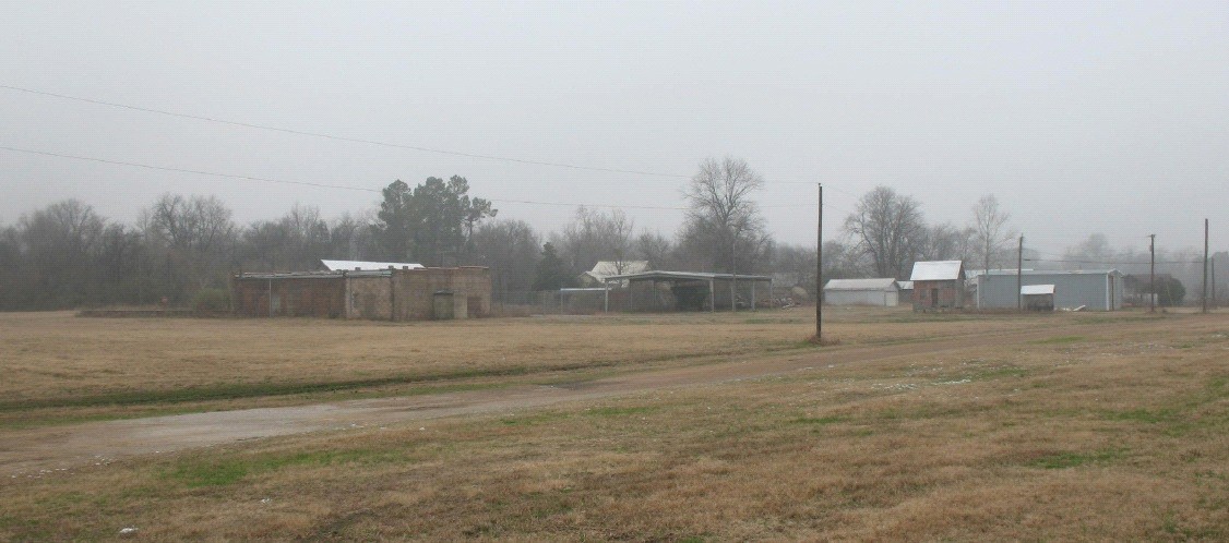
                    The brick building is what remains of the row of shops and Post Office.  Depot would have been just to the right.
                     The field to the left was like the city park.  It was the site of carnivals and in the 1960's a Little League baseball field.
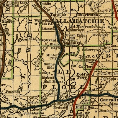
Minter City in 2009

FIGURES


Map of 1888
Figure 1.    Map of 1888
  The Y&MV railroads are highlighted in RED and the BROWN colors.  The Richmod & Danville railroads are highlighted in
BLACK.
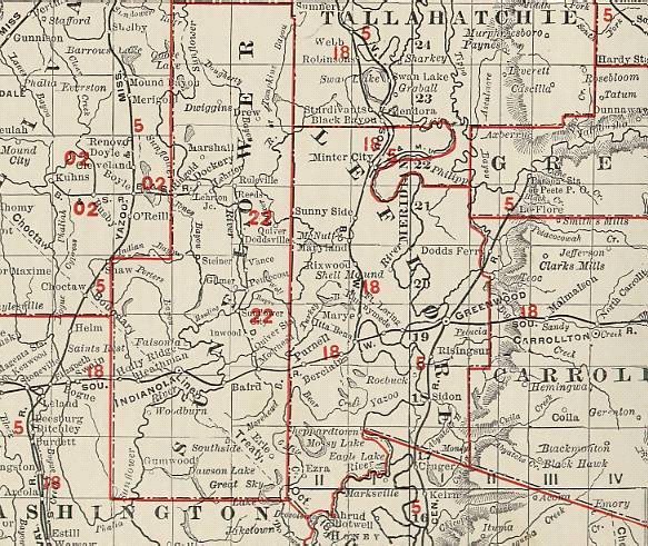


Map of 1895
Figure 2.    Map of 1895


Map of 1919
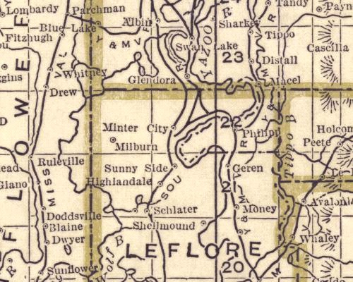
Figure 3.     Map of 1919


SOURCES AND ACKNOWLEDGEMENTS

   What was the point?  I wanted to delve into the history of my old town to see what I could find.  As with the study of genealogy, I wanted to know the history but also wanted to make the trip for the next traveler along the path just a little easier.  Along that line, I plan to give copies of this to as many people as might want it.  I want them to continue the search.  All are free to question my research or conclusions.  Marie and I said, “If we can’t find it, we’ll put down what we know and let others find it for us”.  Well, at least it would have been ‘found’.  History will be lost if it is not caught and put on paper as it is found.  The sources listed below have been invaluable in my search.  I list them in general terms so the next traveler can find materials.  Will the internet as we know it be around in another half century – or will it be improved?  Can we ask the same thing about the books cited?  Like this old town, history WILL change.

  1. Alabama Maps.us.edu website for maps
  2. Alan Lind’s book “From the Great Lakes to the Gulf, the Story of the Illinois Central RR”
  3. Edgar B. Smith III –friend I grew up with whose grandfather’s story put some of the parts into place but scrambled others   
  4. Illinois Central RR archives website
  5. Illinois Central 1916 timetable loaned to me by a now-deceased friend, Sid Langhart
  6. Illinois Central Historical Society and the Green Diamond magazine
  7. Louis R. Saillard’s “Delta Route” for the story of the C&G
  8. Marie Nutt for getting the project started, for the use of the Southern 1917 timetable, and for her assistance in finding things out from her father, and for providing the many valuable web links.
  9. Robert Tomb – the first person I met online who had ever heard of Minter City – for photos and leads to informaton
  10. Southern Railway 1917 timetable info given to me by Marie Nutt
  11. Tony Howe’s website “logging railroads”
  12. Tom Lucas, Tony Howe and all the contributors to the “Magrails” Yahoo group who gladly answered my questions
  13. 1895 Map of Mississippi found on the web


    If you have any information on the Yazoo and Mississippi Valley Railroad,
      contact me at Newton Cole.


Figure 4.    Map of 1934 & 1935
Maps of Minter City from 1934 & 1935
Source:   Alabama Maps.us.edu website

4A.  Map of Minter City.  BM 143 is location of the School.      The Y&MV is a spur that goes directly West then turns South.
An old rail bed is visible that angles off towards the North.  This was the SRM line and is now the location of Hiway 49E.
Map of Minter City

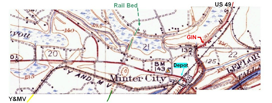
4B.  Section of Map showing the Y&MV that continues South from above map and ends at Avent Chapel.
        In the upper Right corner, next to "City", is the end of the rail that connected with the Minter City Oil Mill until the 1960's.
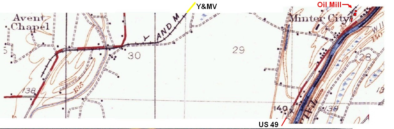
Map of Minter City


Return to Top

Water Tower In Minter City
Web Links about Minter City

Frank Pleasants Sturdivant (1917-1996) A resident who lived farmed on the East side of the Tallahatchie River. He was Deputy Group Commanding Officer of 39th Bomb Group.  Click for Biography.

Newton F. Cole (1917-1992) - A resident for 60+ years.  Biography of his service during WW2 with the 85th Infantry Division in Italy.

The Bottle Tree Man -  A commericial website by Dudley Pleasants.  Click for site.


1938 Minter City H.S. Football team
1938 Football Team of Minter City High School
Sign reads: "FRANK STREATER CONSOLIDATED SCHOOL"
Person holding football is my Uncle Jimmie Hill


Return to Main Menu

Return to Site Map for Custermen.com


Key Words:  History of Yazoon and Mississippi Valley Railroad Y&MV   Columbus and Greenville C&G Southern Railway of Mississippi SRM  Swiftown Morgan City Glendora Schlater Belzoni